


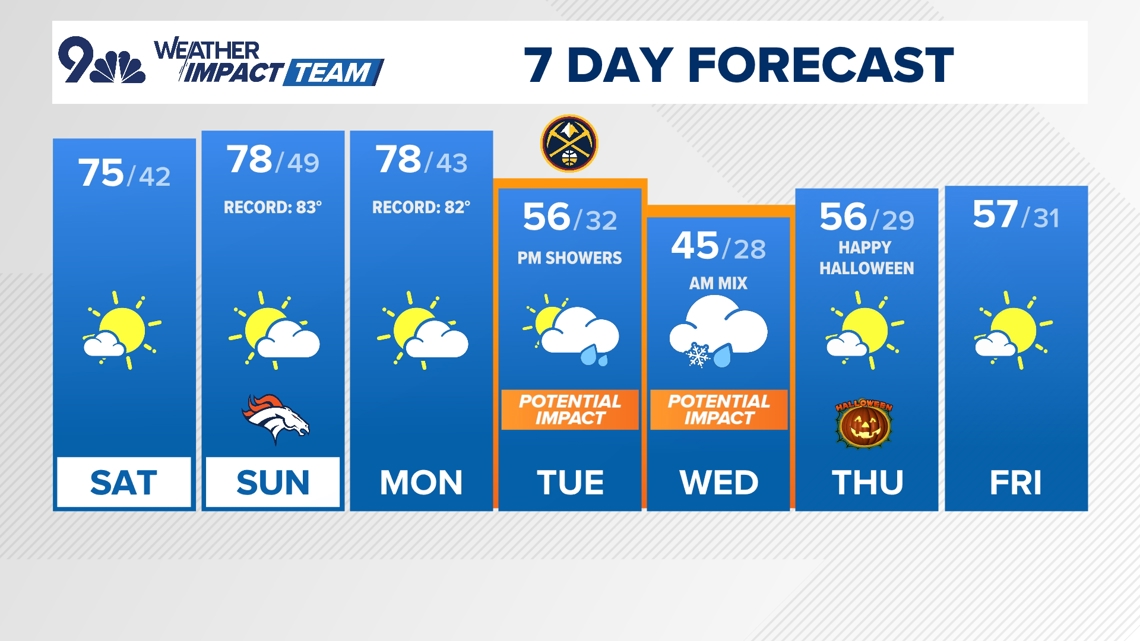
High temperatures in the upper 70’s through Monday with dry conditions. Winter storm comes Tuesday.
DENVER — FORECAST BY: 9NEWS Weather Impact Team Meteorologists Cory Reppenhagen
THE FORECAST AT A GLANCE:
Another chilly morning on Saturday with highs in the upper 30’s in the Denver area. There is a frost advisory for some areas east and south of Denver.
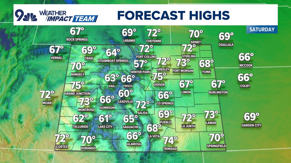
It’ll stay warm through the upcoming weekend, with highs spiking into the mid-70s on Saturday and we’ll be near 80° on both Sunday and Monday, which would be just a few degrees shy of records on both days.
We’ll have to watch for some wind and high fire danger on Sunday and Monday ahead of our next storm system that arrives on Tuesday. That storm will bring us our first widespread freeze (32° or lower temperature) across the I-25 urban corridor.
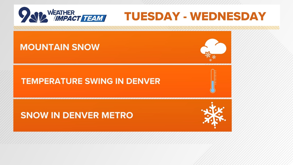
Watch for a big temperature swing from the upper 70’s on Monday to freezing by Wednesday morning.
It looks like mountain snow could start on Tuesday morning with more than a foot possible in parts of the high country by Wednesday night. Rain showers are likely in Denver and parts of the Front Range by Tuesday evening, switching to a rain/snow mix on Wednesday morning.
At this point, snow accumulation is not highly likely in Denver, but we should see some snow falling. It does only take a tenth of an inch to register that first official snow, however. The higher suburbs have a decent shot to get some light snow accumulation on grassy areas and roof tops.
Your Halloween forecast is looking chilly but dry as Denver dodges the Halloween storm once again this year by a matter of just a couple days. It will start out cold Thursday morning with temperatures in the upper 20’s, but it should rebound into the upper 50’s by sunset. Expect temperatures to be in the 40s when the kiddos head out for trick-or-treating. They’ll drop into the mid 30s by late Thursday night.
A trailing storm system could impact Colorado by the weekend after Halloween.


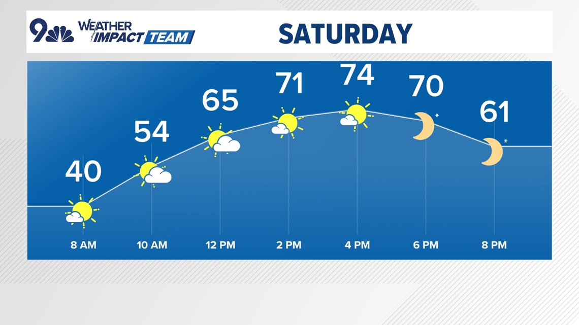

SATURDAY: Mostly sunny and warm, high 74. Partly cloudy overnight, low 42.
SUNDAY: Mostly sunny and warm, high 78. Mostly cloudy overnight, low 49.
MONDAY: Partly cloudy and breezy, high 78. Partly cloudy overnight, low 43.
TUESDAY: Partly cloudy and much cooler with afternoon rain showers, high 56. Mostly cloudy, with rain/snow showers overnight, low 32.
WEDNESDAY: Mostly cloudy and chilly with morning snow showers, high 45. Partly cloudy overnight, low 28.
THURSDAY (HALLOWEEN): Partly cloudy and seasonal, high 56. Partly cloudy overnight, low 29.
FRIDAY: Mostly sunny and cool, high 57. Mostly clear and chilly overnight, low 31.

CLOSINGS: Latest closings and delays in Colorado
WEATHER LINE 9: Updated weather forecast information at 303-871-1492.
TRAFFIC CENTER: Keep up on crashes and travel times here
If you have a weather report, photo or video to share, you can contact the 9NEWS Weather Team in these ways:
EMAIL: Weather photos, videos
Share updates on our Facebook wall: facebook.com/9weather
Tweet your updates using the hashtag #9WX or tweet us at twitter.com/9NEWSWeather
Download the 9NEWS app:
iTunes: on9news.tv/itunes
Google Play: on9news.tv/1lWnC5n
9NEWS Weather Impact Team
The 9NEWS Weather Impact Team of Kathy Sabine, Cory Reppenhagen, Laurann Robinson, Keely Chalmers and Chris Bianchi update the Denver weather forecast multiple times each day.
Bookmark this link to always have the latest forecast from 9NEWS. The team values your local weather reports and often features your photos and videos during weather segments in all newscasts.


More Stories
A nation torn between Russia, the West: Your simple guide to Georgia’s vote
Harris and Beyonce rally on abortion rights in Texas
‘Does a Dalit’s life have no value?’: The murder of a teenage girl in India