


9NEWS has issued Weather Impact Days for Saturday night- Sunday morning for widespread rain, mountain snow.
DENVER — FORECAST BY: 9NEWS Weather Impact Team Meteorologist Laurann Robinson
FORECAST AT A GLANCE:
Enjoy your last warm day, Friday, before big changes move in for the weekend!
Afternoon highs will reach the middle to upper 80s, Friday, staying mild through the evening hours, with overnight lows in the middle 50s.
Our next system approaches midday Saturday, and it’s a going to be a big one! We’ll start the day sunny, Saturday, then midday cloud cover will start to move in, along with gusty winds, up to 20 to 30 mph. By Saturday evening, prepare for widespread rain showers across the front range, with some heavy, wet mountain snow.
Winter Weather Advisories have been issued for Rocky Mountain National Park, the mountains of Summit County, the Mosquito Range and Indian Peaks, Saturday evening through noon Sunday. These areas can expect up 4 to 9 inches of wet snow, causing slick road conditions.
To the south, areas near the San Luis Valley will be under a Marginal Risk for severe weather, with gusty winds, heavy downpours and lightning/thunder being the biggest impacts.
By Sunday morning, the front range is likely to see up to an inch of rain, while the high country could see several inches of snowfall. Once this system moves out, we’ll see some partial clearing, with chilly temperatures left behind. Bundle up as highs will max out in the middle 50s!
Monday, temperatures rebound a bit, with seasonal highs in the middle 70s. We’ll also watch for another round of late-day showers.
Another cooler day is in-store for Tuesday, with afternoon temperatures dropping again, into the upper 60s. Keep an eye out for slight rain chances.
By the middle of next week, we’ll see some sunshine return, with temperatures starting to level out, in the middle 80s to lower 90s, Wednesday, Thursday and Friday.
Cooler, wet weather moving in

FRIDAY: Mostly sunny and warm, high 89. Mostly clear overnight, low 54.
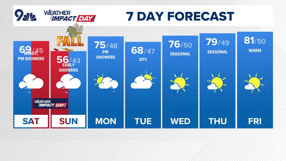
SATURDAY: Partly cloudy early, then turning cloudy and cooler, with late-day showers, high 69. Cloudy overnight with showers continuing, low 45.
SUNDAY: Cloudy and chilly, with lingering early showers ahead of afternoon partial clearing, high 56. Partly cloudy overnight, low 43.
MONDAY: Mostly sunny and seasonal, with late-day showers, high 75. Mostly cloudy overnight, low 48.
TUESDAY: Mostly cloudy and cooler, with a slight chance for showers, high 68. Partly cloudy overnight, low 47.
WEDNESDAY: Mostly sunny and seasonal, high 76. Mostly clear overnight, low 50.
THURSDAY: Mostly sunny and seasonal, high 79. Mostly clear overnight, low 49.
FRIDAY: Mostly sunny and warmer, high 81. Partly cloudy overnight, low 50.
CLOSINGS: Latest closings and delays in Colorado
WEATHER LINE 9: Updated weather forecast information at 303-871-1492.
TRAFFIC CENTER: Keep up on crashes and travel times here
If you have a weather report, photo or video to share, you can contact the 9NEWS Weather Team in these ways:
EMAIL: Weather photos, videos
Share updates on our Facebook wall: facebook.com/9weather
Tweet your updates using the hashtag #9WX or tweet us at twitter.com/9NEWSWeather
Download the 9NEWS app:
iTunes: on9news.tv/itunes
Google Play: on9news.tv/1lWnC5n
9NEWS Weather Impact Team
The 9NEWS Weather Impact Team of Kathy Sabine, Cory Reppenhagen, Laurann Robinson, Keely Chalmers and Chris Bianchi update the Denver weather forecast multiple times each day.
Bookmark this link to always have the latest forecast from 9NEWS. The team values your local weather reports and often features your photos and videos during weather segments in all newscasts.


More Stories
Petition to force Lakewood developers to create parks gains thousands of signatures
Windsor defeats Severance in 9Preps Game of the Week
Horse released from hospital after being injured in Alexander Mountain Fire evacuation