


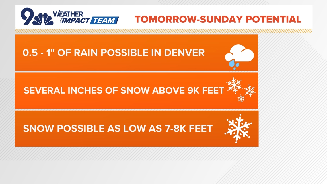
We’ve issued a Weather Impact Day for tomorrow night and Sunday morning for widespread rain and mountain snow.
DENVER — FORECAST BY: 9NEWS Weather Impact Team Meteorologist Chris Bianchi
THE FORECAST AT A GLANCE:
One more sunny, dry and warm day before cooler, wet weather moves in!
A mild evening tonight, for most of Colorado, but a Frost Advisory has been issued for the San Luis Valley. Watch for lows to drop as low as 33 degrees, between 3 to 8 a.m. Friday.
Friday afternoon, we’ll see another sunny day with highs reaching the middle 80s. Take advantage because big changes are in-store for the weekend!
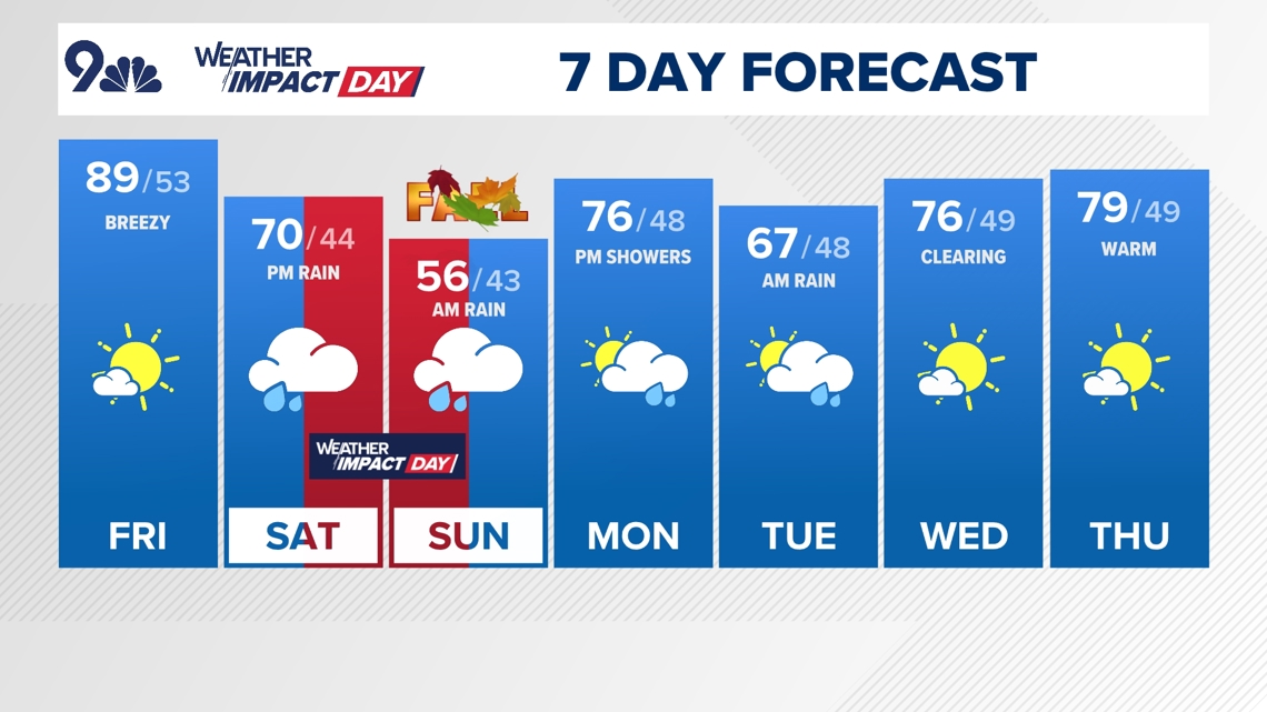
Saturday, we’ll start the day dry, with some early sunshine. Expect clouds to move in by the afternoon hours, causing highs to peak in the upper 60s/lower 70s, along with gusty winds. By Saturday evening, scattered rain showers takeover, becoming heavy during the overnight hours.
By Sunday morning, we should prepare for up to an inch of rain across the front range, and a few inches of snow in the high country. Northern areas of the foothills and mountains could see between 3 to 7 inches of early-season snow! Meanwhile, across the front range, afternoon temperatures will drop all the way into the upper 50s.
A Winter Weather Advisory has been placed for the western Mosquito Range and eastern Sawatch Mountains (above 11,000 ft), from noon Saturday until noon Sunday. These areas should expect up to 7 inches of snow, with winds gusting up to 35 mph. Watch for blowing snow to reduce visibility.
Afternoon highs rebound into the middle 70s, Monday, but we’re also tracking more late-day scattered shower possibilities. Shower chances linger into the early Tuesday hours, as lows drop again, peaking in the middle 60s.
Drier, more seasonal weather returns for the middle of next week, with afternoon temperatures in the middle to upper 70s, Wednesday and Thursday, respectively.


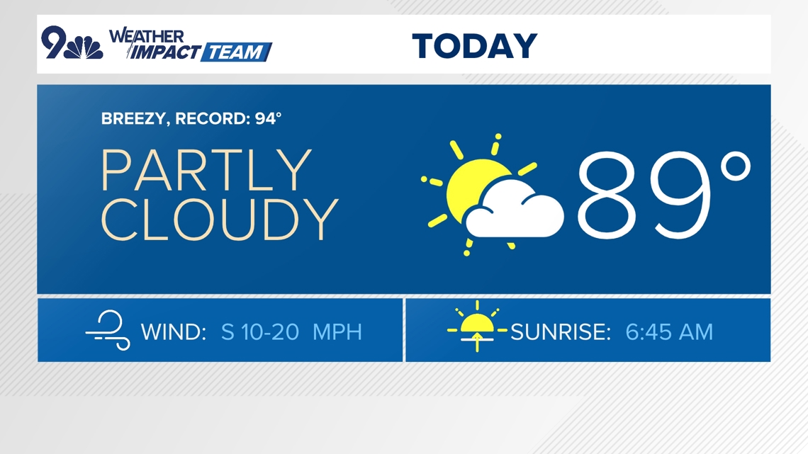
FRIDAY: Mostly sunny and warm, high 89. Mostly clear overnight, low 53.
SATURDAY: Partly cloudy early, then turning cloudy and cooler with late-day showers likely after about 3 p.m., high 70. Cloudy overnight with showers continuing, low 44.
SUNDAY: Cloudy with lingering early showers ahead of afternoon partial clearing, high 56. Partly cloudy overnight, low 43.
MONDAY: Partly cloudy and mild with late-day showers, high 76. Mostly cloudy overnight, low 48.
TUESDAY: Mostly cloudy with an early chance for showers, high 67. Partly cloudy overnight, low 48.
WEDNESDAY: Mostly sunny and mild, high 76. Partly cloudy overnight, low 49.
THURSDAY: Mostly sunny and seasonal, high 79. Partly cloudy overnight, low 49.
FRIDAY: Mostly sunny and warmer, high 81. Mostly clear overnight, low 51.

CLOSINGS: Latest closings and delays in Colorado
WEATHER LINE 9: Updated weather forecast information at 303-871-1492.
TRAFFIC CENTER: Keep up on crashes and travel times here
If you have a weather report, photo or video to share, you can contact the 9NEWS Weather Team in these ways:
EMAIL: Weather photos, videos
Share updates on our Facebook wall: facebook.com/9weather
Tweet your updates using the hashtag #9WX or tweet us at twitter.com/9NEWSWeather
Download the 9NEWS app:
iTunes: on9news.tv/itunes
Google Play: on9news.tv/1lWnC5n
9NEWS Weather Impact Team
The 9NEWS Weather Impact Team of Kathy Sabine, Cory Reppenhagen, Laurann Robinson, Keely Chalmers and Chris Bianchi update the Denver weather forecast multiple times each day.
Bookmark this link to always have the latest forecast from 9NEWS. The team values your local weather reports and often features your photos and videos during weather segments in all newscasts.


More Stories
As Russia’s war escalates, will Ukraine down the Kerch Bridge in Crimea?
Oprah’s Kamala Harris fundraiser: Does her support swing elections?
In Israel, some want war with Hezbollah, others are worried