


Winds will be the main story today, with gusts up to 60 mph in the foothills, and high fire danger as a result.
DENVER — FORECAST BY: 9NEWS Weather Impact Team Meteorologists Chris Bianchi, Keely Chalmers
THE FORECAST AT A GLANCE:
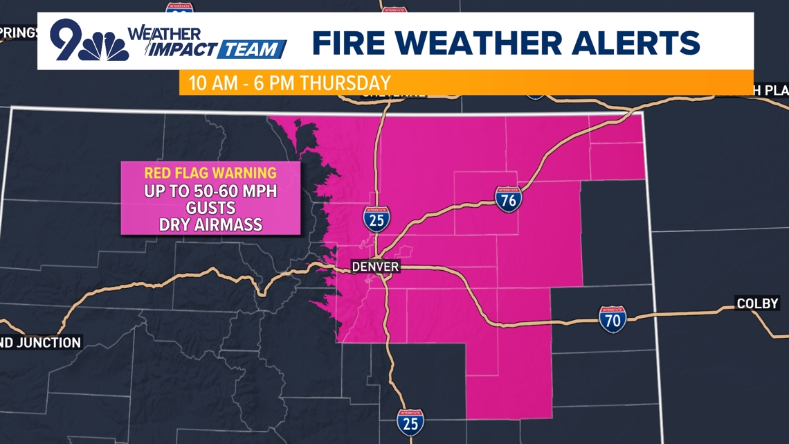
We’re looking at a windy and dry afternoon across most of Colorado, which will increase our fire danger. There’s a Red Flag Warning (fire weather warning) between 10 a.m. and 6 p.m. as a result for those elevated fire weather concerns.
Wind will be the big story today with gusts up to 60 mph in the wind-prone foothills (especially in Larimer and Boulder Counties) and some 50 mph gusts on the Eastern Plains. Denver will probably have top gusts in the 35-40 mph range today before those winds relax rather quickly tonight.
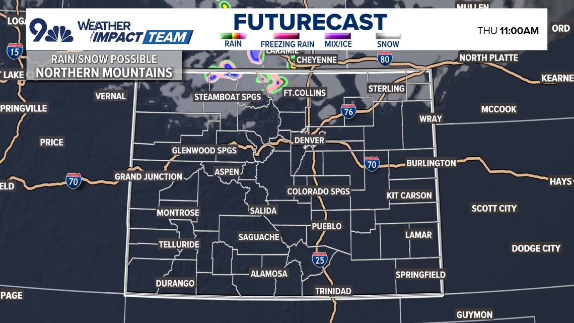
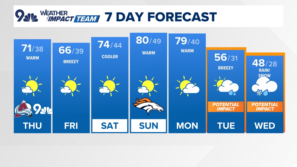
Highs will top out in in the low to mid 70s in Denver today (we hit 77° yesterday). A cold front sweeping across the plains will cool things off, so we’ll be closer to seasonal for tomorrow. We’ll have a few high clouds in Denver this afternoon and the snow in northern mountains will taper off.
As mentioned, we’ll have a slightly cooler day tomorrow with a high in the mid-60s before we warm right back up again for Saturday (mid-70s) and especially Sunday and Monday, with highs around 80° both of those days.
Then, we’ll see some big changes roll in next Tuesday and Wednesday. Highs will tumble into the 40s and 50s in Denver with our first freeze of the season looking very likely next week, with rain on Tuesday night potentially flipping to snow by Wednesday morning. Snow amounts look minimal, with perhaps a bit of slush in Denver, but it might count as our first snow of the season.
Until then, watch for the higher fire danger today across northeastern Colorado!

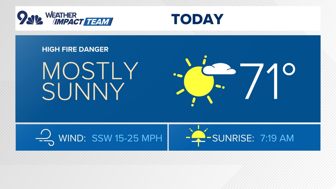


THURSDAY: Mostly sunny, breezy, and warm, high 71. Mostly clear overnight, low 38.
FRIDAY: Mostly sunny and a bit cooler, high 66. Mostly clear overnight, low 39.
SATURDAY: Partly cloudy and warm, high 74. Partly cloudy overnight, low 44.
SUNDAY: Partly cloudy and warm, high 80. Partly cloudy overnight, low 49.
MONDAY: Mostly sunny and warm, high 79. Partly cloudy overnight, low 40.
TUESDAY: Partly cloudy and much cooler, with a chance of rain showers, high 56. Mostly cloudy, with a chance for rain or snow overnight, low 31.
WEDNESDAY: Mostly cloudy and chilly, with morning snow showers and afternoon sunshine, high 48. Mostly clear overnight, low 28.
THURSDAY (HALLOWEEN): Mostly sunny but chilly, high 58. Mostly clear overnight, low 30.

CLOSINGS: Latest closings and delays in Colorado
WEATHER LINE 9: Updated weather forecast information at 303-871-1492.
TRAFFIC CENTER: Keep up on crashes and travel times here
If you have a weather report, photo or video to share, you can contact the 9NEWS Weather Team in these ways:
EMAIL: Weather photos, videos
Share updates on our Facebook wall: facebook.com/9weather
Tweet your updates using the hashtag #9WX or tweet us at twitter.com/9NEWSWeather
Download the 9NEWS app:
iTunes: on9news.tv/itunes
Google Play: on9news.tv/1lWnC5n
9NEWS Weather Impact Team
The 9NEWS Weather Impact Team of Kathy Sabine, Cory Reppenhagen, Laurann Robinson, Keely Chalmers and Chris Bianchi update the Denver weather forecast multiple times each day.
Bookmark this link to always have the latest forecast from 9NEWS. The team values your local weather reports and often features your photos and videos during weather segments in all newscasts.


More Stories
Broncos player wounded in shooting after leaving strip club
Prosecutors recommend resentencing Erik and Lyle Menendez in 1989 killings of their parents
Why is Israel targeting Al Jazeera correspondents in Gaza?