


Elevated fire danger with windy warm conditions on Thursday. Slow cooling trend ahead of Friday showers and mountain snow. Winter weather travel advisories posted
DENVER — FORECAST BY: 9NEWS Weather Impact Team Meteorologist Kathy Sabine
FORECAST AT A GLANCE:
We are tracking a weekend storm that will bring cooler weather and much needed moisture for the state over the next few days.
Today a mix of clouds and sun with mild afternoon highs in the mid 70s. Ten degrees above average. a 20% chance for a brief light shower.
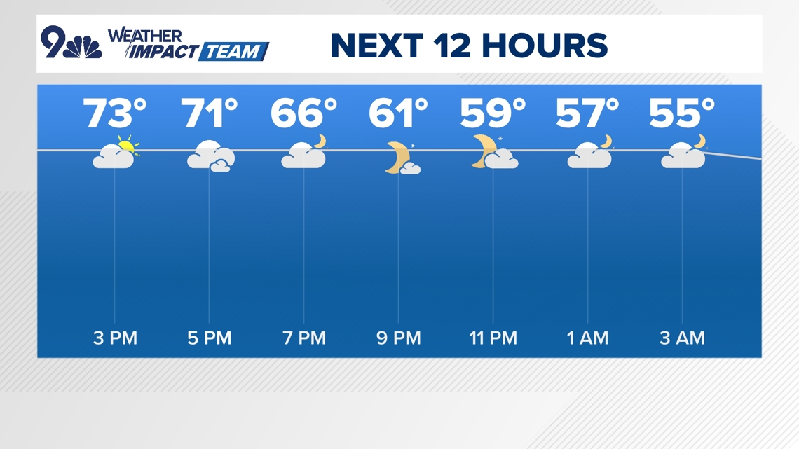
Increasing winds out of the southwest and elevated fire danger ahead of the approaching Pacific trough this afternoon and evening. A Red Flag fire weather warning is in place for the northeastern plains until 6 p.m.
Partly to mostly cloudy skies are forecast this evening with gusty southwest winds and lows in the upper 40s along the front range.
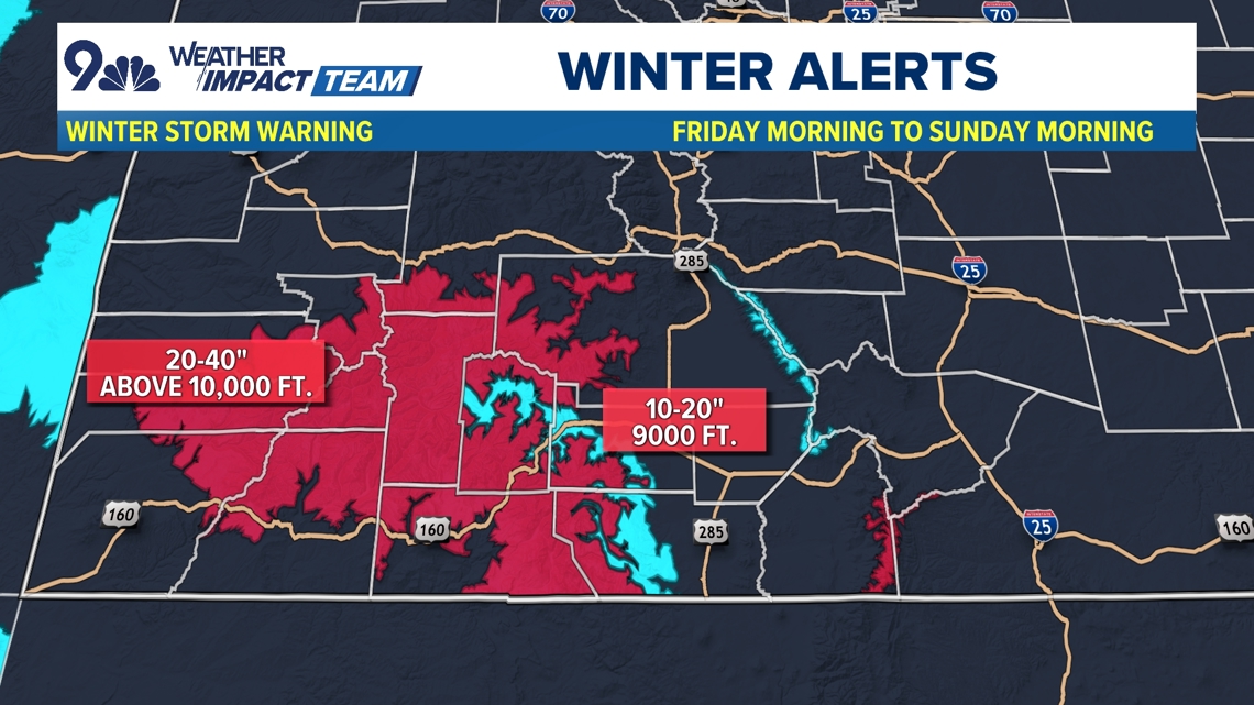
Scattered rain and snow showers will continue into the evening across the mountains. Winter weather and travel advisories are posted for the southern mountains through Sunday for heavy snow and wind.
The main impact of the storm comes on Friday with heavier snow in the mountains. A Winter Storm Warning is out for the southwest mountains for 10-30 inches possible from Friday afternoon to Sunday morning.
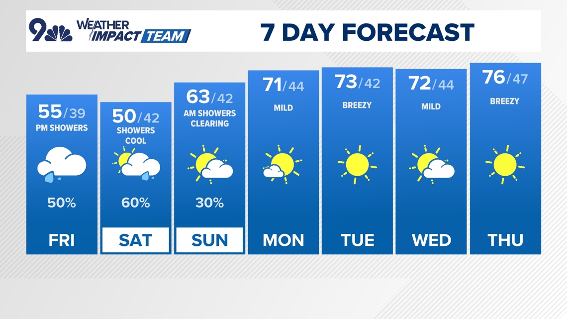
Rain showers will gradually spread across the Front Range on Friday afternoon, with the bulk of the widespread rain showers likely beginning Friday evening or Friday night and lasting into the day on Saturday.
Expect a mostly cloudy and cooler day Saturday with occasional and scattered showers for the front range with afternoon temperatures in the 40s and lower 50s and lows in the middle 30’s. The first freeze is not in the forecast for Denver, but it may come very close. Snow accumulation also remains very unlikely in Denver.
As the storm system exits the area on Sunday, a few isolated showers will be possible on the Front Range but lots of sunshine and warmer temperatures will greet us to start the next workweek.

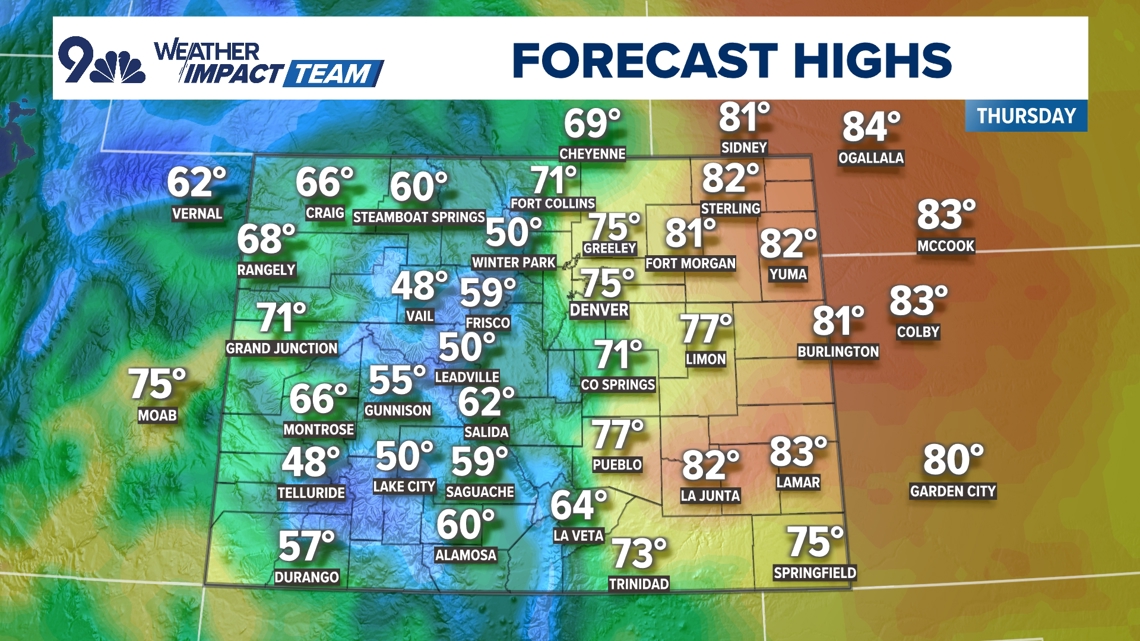


THURSDAY: Partly cloudy, windy and mild, isolated showers, high 75. Partly cloudy overnight, low 48.
FRIDAY: Mostly cloudy and cooler, with afternoon rain showers, high 60. Cloudy with showers overnight, low 37.
SATURDAY: Mostly cloudy and chilly, with scattered showers, high 50. Mostly cloudy overnight, low 39.
SUNDAY: Isolated showers possible at times, high 63. Partly cloudy, low 42.
MONDAY: Mostly sunny and seasonal, high 71. Partly cloudy, low 44.
TUESDAY: Mostly sunny and mild, high 73. Partly cloudy, low 45.
WEDNESDAY: Mostly sunny and seasonal, high 72. Partly cloudy, low 44.
THURSDAY: Mostly sunny and mild, high 76, Partly cloudy, low 44.

CLOSINGS: Latest closings and delays in Colorado
WEATHER LINE 9: Updated weather forecast information at 303-871-1492.
TRAFFIC CENTER: Keep up on crashes and travel times here
If you have a weather report, photo or video to share, you can contact the 9NEWS Weather Team in these ways:
EMAIL: Weather photos, videos
Share updates on our Facebook wall: facebook.com/9weather
Tweet your updates using the hashtag #9WX or tweet us at twitter.com/9NEWSWeather
Download the 9NEWS app:
iTunes: on9news.tv/itunes
Google Play: on9news.tv/1lWnC5n
9NEWS Weather Impact Team
The 9NEWS Weather Impact Team of Kathy Sabine, Cory Reppenhagen, Laurann Robinson, Keely Chalmers and Chris Bianchi update the Denver weather forecast multiple times each day.
Bookmark this link to always have the latest forecast from 9NEWS. The team values your local weather reports and often features your photos and videos during weather segments in all newscasts.


More Stories
Southbound I-225 closed in Aurora for police activity
Pakistan spinners take all 20 England wickets to level Test series
Kenya Deputy President Rigathi Gachagua’s impeachment: Why it matters