


Until then, it’s more of the same with unusually warm and dry conditions expected.
DENVER — FORECAST BY: 9NEWS Weather Impact Team Meteorologist Chris Spears
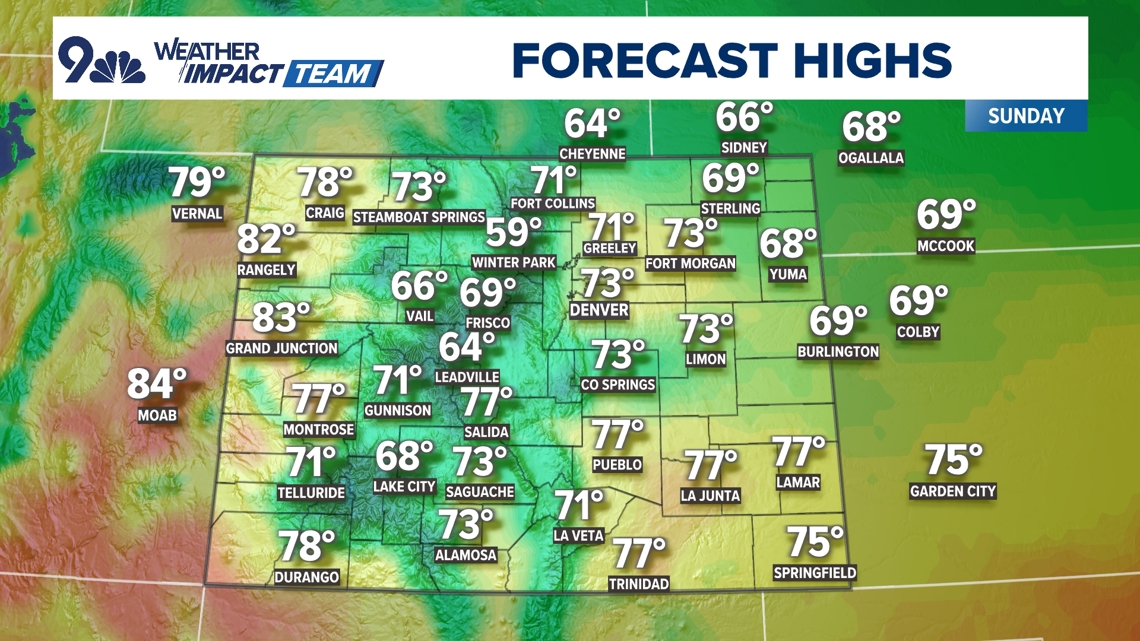
FORECAST AT A GLANCE: Happy Sunday! It’ll be a cooler day for those in Denver and eastern Colorado thanks to a weak cool front that moved through yesterday. After a high of 81° on Saturday, we’ll be 5-10 degrees cooler today with light wind.
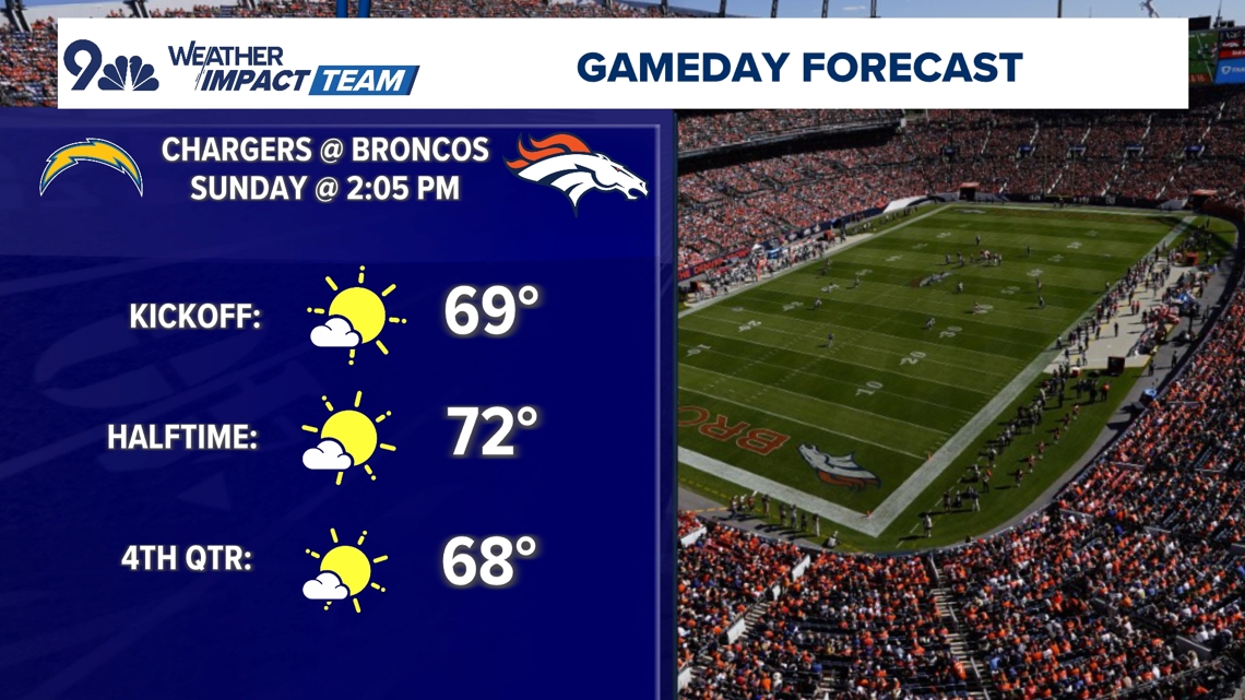
Despite being cooler, we are still above normal for this time of year. Denver’s average high for Oct. 13 is 66 degrees. For those headed to catch the Broncos take on the Chargers, you’ll have comfortable temps with readings within a few degree of 70 the entire time.

Western Colorado and most of the mountains really didn’t experience the cool front so highs once again will return to the 60s and 70s, with a few lower 80s in western valleys. By this afternoon, some clouds will drift through the region and there is a very small chance to see a few showers pop up in the central mountains.

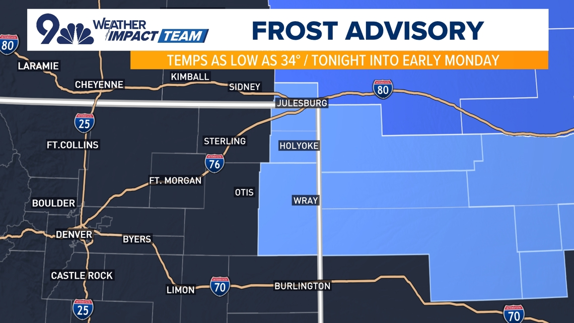
With mostly clear skies overnight and little to no wind, we’ll see effective radiational cooling, especially on the far northeast plains, where lows could get close to freezing. These conditions are perfect for the formation of frost. The National Weather Service has issued a Frost Advisory for Sedgwick, Phillips and Yuma counties overnight tonight.

The week ahead will be more of the same with high pressure still the dominant feature over the Rockies. Temperatures will remain above normal and for the most part it will be dry.
The middle of the week will turn windy at times due to an approaching storm system. That will significantly elevate the fire danger and we could even see some areas reach Red Flag criteria.
By Friday, that storm will begin to impact the region. There are still a lot of details to iron out with regard to how this storm looks, but right now, we are showing much cooler temperatures with the potential for lower elevation rain showers and higher elevation snow showers. Stay tuned throughout the week as we continue to fine tune those details for you.

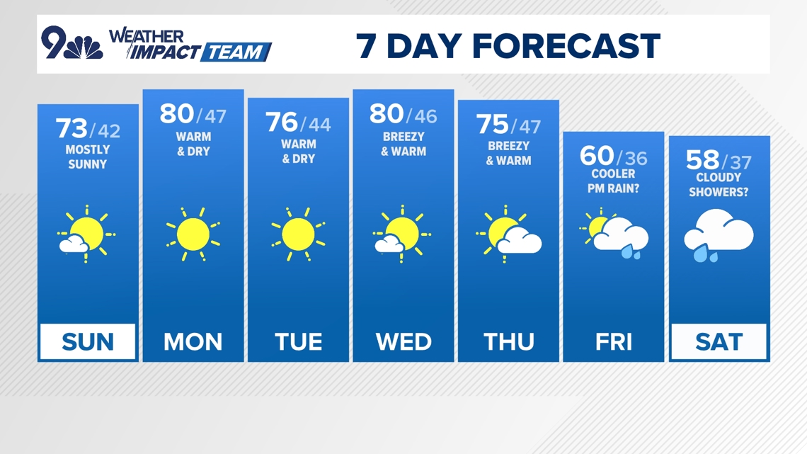
SUNDAY: Not as warm with scattered afternoon clouds. High 73, low 42.
MONDAY: Mostly sunny and very warm with a high around 80. Mostly clear at night, low 47.
TUESDAY: Mostly sunny and warm, high 76. Mostly clear overnight, low 44.
WEDNESDAY: Continued very warm with breezy conditions during the afternoon, high 80. Partly cloudy overnight, low 46.
THURSDAY: Breezy and still quite warm with elevated fire weather, high 75. Partly cloudy overnight, low 47.
FRIDAY: Turning cooler with a chance for afternoon rain showers, high 60. Cloudy overnight 36.
SATURDAY: Mostly cloudy with scattered showers possible. High 58, low 37.
CLOSINGS: Latest closings and delays in Colorado
WEATHER LINE 9: Updated weather forecast information at 303-871-1492.
TRAFFIC CENTER: Keep up on crashes and travel times here
If you have a weather report, photo or video to share, you can contact the 9NEWS Weather Team in these ways:
EMAIL: Weather photos, videos
Share updates on our Facebook wall: facebook.com/9weather
Tweet your updates using the hashtag #9WX or tweet us at twitter.com/9NEWSWeather
Download the 9NEWS app:
iTunes: on9news.tv/itunes
Google Play: on9news.tv/1lWnC5n
9NEWS Weather Impact Team
The 9NEWS Weather Impact Team of Kathy Sabine, Cory Reppenhagen, Laurann Robinson, Keely Chalmers and Chris Bianchi update the Denver weather forecast multiple times each day.
Bookmark this link to always have the latest forecast from 9NEWS. The team values your local weather reports and often features your photos and videos during weather segments in all newscasts.


More Stories
India’s envoy to Canada rejects involvement in Sikh activist’s killing
Adolescente muere en tiroteo con la policía tras informe de agresión en Aurora
‘Smile 2’ grinning to No. 1 at box office; ‘Anora’ glitters in limited release